

Deep beneath our feet is one of the government’s biggest and most well-kept secrets, bunkers designed to be America’s last stand against foreign adversaries, a place protected against nuclear weapons and their devastating aftermath.
Officially, what this story will discuss and reveal doesn’t exist, it has never been acknowledged, even as countries such as China now boast about their equivalents; the local area represents America’s last hope of survival – a seed to ensure the flame of our democracy never goes out.
Those who live above, residents who call the local area home, are sacrifices to the nation, like those living nearby the missile fields out west, ensuring that America will prevail while giving one last knock-out punch to whatever enemy makes the fatal decision to attack our homeland.
As relations with China weaken, with them eyeing a potential move on Tawain, sites like these are an impenetrable reminder that America is unbeatable and any nation who desires to bring harm to the United States will have harm done unto them.
Near the conclusion of World War II, when the United States dropped two atomic bombs on Hiroshima and Nagasaki, the world forever changed; suddenly, the destructive power of dozens upon dozens of bombers could be condensed into a single bomb, capable of vaporizing an entire town.
By the end of the decade, the Soviets would successfully test the weapon, ending America’s exclusivity with the nuclear bomb, followed soon thereafter by the United Kingdom, France and the People’s Republic of China.
For a while, the only means of delivery would be via a heavy bomber, giving advance notice of an impending attack – which would take hours to arrive, but those would soon but superseded by intercontinental ballistic missiles, capable of striking a target halfway across the world in as little as 30 minutes.
The destructive power of the nuclear bomb is inconceivable when compared to traditional ordinances, the pressure wave alone is capable of destroying buildings and critical infrastructure miles beyond the direct area of impact.
Soon the government realized they had a very real need for structures capable of augmenting that of traditional bunkers utilized during previous conflicts.
They tunneled into Cheyenne Mountain, they constructed under Mount Weather, they built onto the Greenbrier, they dug under Camp David and they mined into Raven Rock Mountain, all in the hopes of protecting the government and military – but there was a fatal flaw, each was unlikely to survive a direct hit by a nuclear bomb, and as instruments on bombers and ICBMs became more accurate, these advanced bunkers, many of which are still in use today, were destined more to become tombs than places of refuge.
Officially, those sites are all we still have, during 9/11, President Bush was taken floors under Offutt Air Force Base near Omaha, Nebraska, the home of the U.S. Strategic Command; designated members of Congress to under Mouth Weather.
The RAND Corporation was tasked with locating geological formations inside the United States that could be excavated to create large underground installations, constructed deep below, impenetrable by even the most capable bunker-busting nuclear weapons.
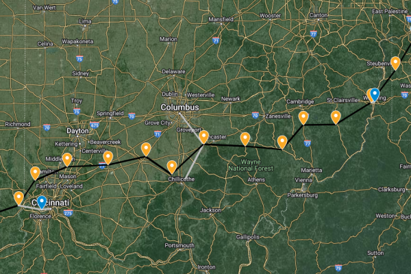
One such potential site identified by researchers was the McConnelsville, Ohio, area due to the quality of the Maxville Limestone which underlies the Pennsylvania System. In total, twelve potential locations were given.
Y-City News previously identified that the local area is one of the only spots in the country that wasn’t declassified as part of the public release of KH-9 spy satellite imagery, which was captured between 1971 and 1984.
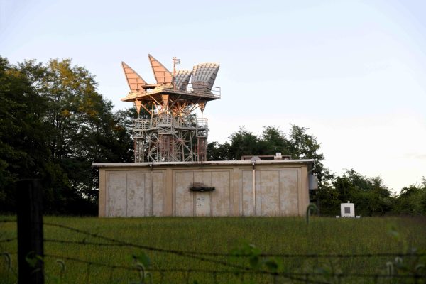
Additionally, the exact area of missing coverage just happens to feature linkage in the AT&T ‘Long Lines’ Microwave Tower Network. The country was dotted with such structures, but these were different, they were hardened to survive the nearby explosion of a nuclear bomb.
Built in the mid-1960s, these towers were designed to be operational in a post-attack scenario, fitted with battery and diesel backups, they offered up to two weeks of continued service without the need for additional replenishments.
Once these hardened towers could be geolocated and mapped across the country, using an algorithm to determine the degree of change from each point in its linkage, to the east and west, respectively, the angle for each site could be calculated.
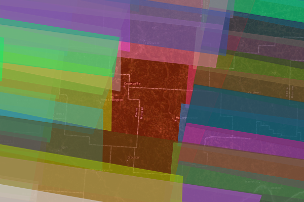
What that analysis did was show outliers from the norm. In Ohio’s case, as seen in the map below, it identified deviations in the areas of McConnelsville and Chillicothe, the latter of which was formally the emergency relocation site for the Federal Communications Commission’s Radio Intelligence Division.
The areas of Perry and Morgan Counties, however, were never officially featured in any government emergency relocation planning.
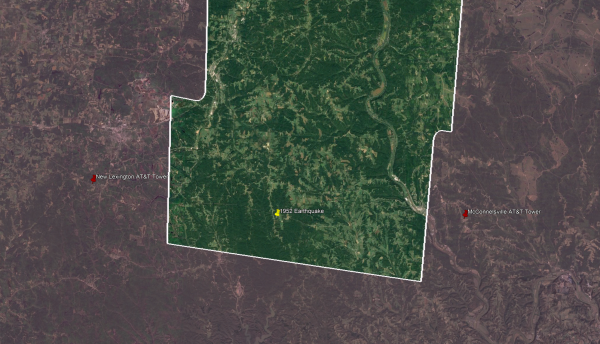
In 1952 and in 1953, the area of non-declassification featured two earthquakes, with many residents in the vicinity, most of whom were miners, recalling that the second sounded like ‘a distant explosion.’ That second earthquake doesn’t appear on many public earthquake catalogs; also, neither has seemed to garner any research, such as to identify potential fault lines.
Nearby in Licking County, the site of Boeing’s Guidance Repair Center, which is responsible for ‘maintaining the readiness and modernization of guidance and navigation systems for our nation’s nuclear-capable platforms,’ the company boasts that the underground facility is in one of the most geologically stable places in the Contiguous United States.
The Muskingum River Power Plant, which began operating in 1953, is also close by, with what is now called the West Millersport – Muskingum River Transmission Line running directly over the point above ground where the earthquakes were recorded. The radio waves between the hardened McConnelsville and New Lexington AT&T ‘Long Lines’ Towers also passed directly above.
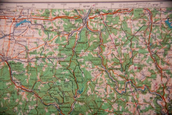
During the First Cold War with the Soviets, each closely watched the other, planners in the East were so detailed in the mapping of the world that the height of bridges in Muskingum County, for example, even on rural roads, were recorded on their foreign maps of the United States.
The openness of American society also aided that effort, maps of everything from our roads to our electric transmission lines were available for anyone to view or purchase, the same was not true about the Soviet Union.
When the union of countries collapsed, leaders in Moscow ordered everything be destroyed, from invasion plans of Europe to details for ongoing intelligence operations against the West to maps of the United States; as one might imagine, those orders were not followed.
Y-City News was able to purchase original maps of a sizable portion of the United States, which we have found to be magnificently detailed, often better than local maps of their era, however, near the town of Moxahala, Ohio, we noticed a century-old rail line was missing. The cartographers in Russia had managed to obtain the clearance of rural township bridges but missed a significant route of travel. The error is even more perplexing as Soviet and Russian military doctrine relied heavily on rail lines and thus it was often over-emphasized in their intelligence-gathering operations; no other such errors were found following a thorough search of the remaining maps.
The cartographers also placed a town slightly west of Moxahala on their maps, where in actuality none ever existed. It’s important to note that these maps held by our news organization were from one of the former Soviet states, meaning top intelligence officials in Moscow knew it was likely American or European intelligence would get access to these maps, was it a hidden indicator of acknowledgment that the Soviets knew what was buried beneath or a simple mistake? Because this article relies on open-source, now declassified information, it’s difficult to say, we may truly never know.
To validate that the RAND Corporation document is accurate to where sites were built deep underground, not just proposed locations, we need only look to the tip of Michigan.
Those researchers also identified the Keweenaw Peninsula as an ideal spot for a buried nuclear-hardened bunker, the site of Calumet Air Force Station. The base also just happened to feature military communication linkage through AT&T’s ‘Long Lines’ Microwave Tower Network, the same style built through Ohio, designed to survive the blast wave of a nuclear explosion.
Roughly once a month a Boeing E-4B will travel to and circle the site for training. The plane serves as the National Airborne Operations Center and is a key component of the National Military Command System. Unlike E-6Bs, which are tasked with communicating nuclear launch orders to submarines, for example, the four E-4B ‘Doomsday Planes’ act as an alternative command post should ground-based facilities be inoperable or destroyed. When the President leaves the United States, one accompanies Air Force One, ready to serve the Commander in Chief for wartime activities.
The ultimate purpose of the plane is to ensure that even if command and control facilities like Cheyenne Mountain or Mount Weather are destroyed, there are operators in the sky able to convey the order for a full nuclear retaliatory strike against the attacking nation. While operational plans are highly classified and compartmentalized, it’s plausible that a deeply buried command post under the Keweenaw Peninsula serves as a fallback, should the planes be taken out. This is supported by the area once hosting Project Sanguine. This extremely low-frequency communication system enabled contact with submarines, allowing them to receive the order to launch their nuclear weapons.
Another site listed in the RAND Corporation document was Morgantown, West Virginia.
The town featured a priority teletypewriter (TTY) circuit to the Raven Rock Mountain Complex (also known as Site R – the ‘underground Pentagon’) and was only miles from AT&T’s L3i nuclear-hardened transcontinental communication cable which primarily served the purpose of ordering the launch of intercontinental ballistic missiles in their silos out west.
In the late 90s, Morgantown also experienced surface explosion caused earthquakes, which are typically due to mining, however, aerial photographs identify no such activity during that time or in the immediate vicinity; such activity also does not usually reach the magnitude as was experienced.
The local airport features a National Guard base and the Morgantown Main Campus of West Virginia University hosts a highly accredited underground mining program.
Likewise, the greater area around The Wilds, a private non-profit safari park and conservation center in southeast Muskingum County, on former stripped-mined land, also experienced multiple similar earthquakes around the same time, after official activity had ceased, which has been collaborated with historic aerial photographs.
Retired Major General Robert W. Teater was instrumental, while serving as Director of Ohio’s Department of Natural Resources, in making the exotic animal preserve possible.
The nearby community of McConnelsville features a sizable National Guard base, which hosts training for the Army’s Avenger Missile System. North to Zanesville, the town features an Air National Guard base which was opened just years after the conclusion of the Second World War following the airport being rushed to completion and into service.
Many details, such as the exact location of military fiber paths or sites of particular interest, have been severely limited or withheld entirely to protect national security. Deep underground bunkers, such as those discussed above, serve as a necessary deterrence against our enemies, guaranteeing the survival of the United States.
Do you have information about these sites, other information you think our news organizing should know about or want to bring our attention to a matter that needs investigating? We would like to hear from you. Contact us at (740) 562-6252, email us at contact@ycitynews.com or mail us at PO Box 686, Zanesville, Ohio 43701. All sources are kept strictly confidential.
James Stewart • Mar 7, 2024 at 9:43 pm
More…more…more, please. This is fascinating.