Zanesville is home to one of the only areas of the country not fully declassified as part of the government’s efforts to make historic spy satellite imagery available to the general public, Y-City News has discovered after extensive analysis.
While many of the nation’s top military sites, from Area 51 to Wright-Patterson, have been released along with government relocation centers, such as Mount Weather, the local area is but a handful of sites deemed not appropriate for full public release.
The revelation comes after our publication previously identified concerning behavior from the former U.S. Attorney of the Southern District of Ohio, David DeVillers, in the local area in which foreign intelligence services were said to be monitoring.
Y-City News provided advance notice to many appropriate government agencies ahead of publication – none of which requested a hold or asked us not to publish our findings – a rationale for why the local area was restricted from declassification was not provided.
Satellites capturing imagery from space was America’s solution during the First Cold War to monitoring the Soviet Union when overflights began to become too dangerous for regular operations.
Highly sophisticated cameras were built to expose miles upon miles of film that would be jettisoned back to Earth, captured by a plane in mid-air and then analyzed by various agencies for actionable intelligence.
President Bill Clinton recognized both the historic and environmental resourcefulness of those images and by executive order in 1995 began the process of making them available to the public.
While those images at the time served very useful purposes in a military sense, giving analysts the resolution needed to make out airports, for example, it wasn’t until later iterations that the quality improved enough to allow for the identification of homes or vehicles.
Declassified in 2011, the KH-9 Hexagon program, which operated from 1971 through 1984, gave the public its first real chance at seeing their towns and neighborhoods at a quality resolution – two feet.
Recognizing the potential to use the imagery to track land use changes in our local area, which was heavily strip and surface mined, we inquired as to the program’s coverage.
Over the last decade, staff working on behalf of the United States Geological Survey have ingested that imagery into its archive. To date, there are over half-a-million frames, with each representing roughly 30,000 square miles.
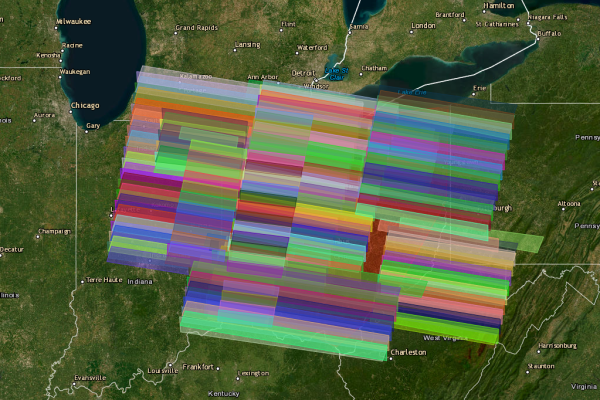
What we soon found, however, was an anomaly – the local area was mostly missing.
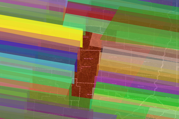
As seen in the above photo, portions of Coshocton, Muskingum, Perry and Morgan Counties are missing. Moreover, the image understates the coverage gap, as the coverage polygons are rough estimates based on four corner point positions provided by the military, and when each frame is individually analyzed, it becomes clear they end at much further west or east than displayed in the map above.
When looking at the entire State of Ohio, for example, the missing gap becomes much more abnormal for its lack of coverage.
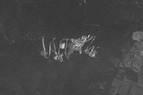
During the program’s history, nearly every location on Earth was captured multiple times. Some spots have been withheld for obvious reasons, such as Lop Nur in China, which is where the country tested its nuclear weapons.
Besides a few select foreign sites, the program has been released nearly in its entirety. Israel, for example, which was caught misusing America’s KH-11 program imagery access to target its nuclear weapons at foreign government sites, has been provided to the public unrestricted.
Only a handful of sites in the Continuous United States have not been fully released. Fallon, Nevada and Pensacola, Florida both host military bases and their restriction are all but assured to be military-related. The remaining three, however, which beyond the local area in Ohio include a spot in West Virginia and a spot in California, are anything but obvious.
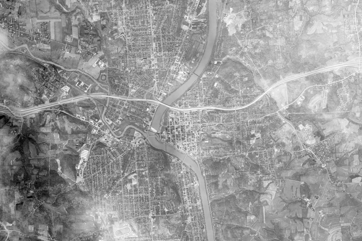
We were able to get a March 21, 1973 frame which included Muskingum County, but it is the only one made available. Most of that frame, which was provided to our organization Thursday afternoon, is excessively cloud-covered but we lucked out and part of Zanesville’s core was visible, as well as a spot down at what is now The Wild’s – letting us locate the Big Muskie.
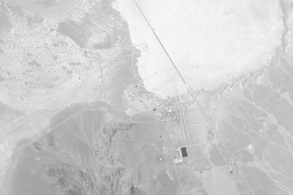
Area 51, a highly classified facility in Nevada, for example, was captured nine times by the various KH-9 spy satellites, but Zanesville just once, according to the official declassified records – additional frames remain classified. Newark was captured three times, Columbus four and Cincinnati fifteen.
Y-City News continues to investigate. Do you have additional information about this revelation, other information you think our news organizing should know about or want to bring our attention to a matter that needs investigating? We would like to hear from you. Contact us at (740) 562-6252, email us at contact@ycitynews.com or mail us at PO Box 686, Zanesville, Ohio 43701. All sources are kept strictly confidential.