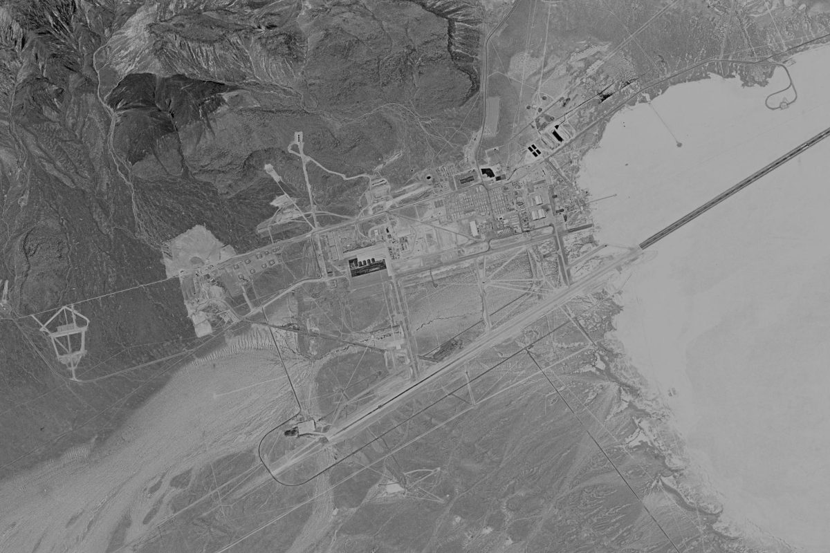
Some of the most sensitive American spy satellite images captured during the First Cold War of the Contiguous United States have been obtained by Y-City News – it brings forth another era of American declassification. Unlike our enemies, the United States believes in freedom for its citizens and ultimately, transparency of its once most Top Secret programs.
The images, some of which are of Area 51, were captured after the Killing of President John F. Kennedy but before the collapse of the Soviet Union; unlike other declassified photos, it shows construction at the base, hangers for craft tested at the site and a sprawling complex designed to give America an overwhelming edge over our foreign adversaries.
The photos – which were obtained from a non-public directory of declassified captures, contain evidence of decades-old superior American craft still yet unknown to the public and construction projects designed to protect the flame of our democracy should a nuclear war occur. Other sites in the accessed hidden repository show images of the country’s most sensitive, yet important installations, including a site in the State of Washington, a site in the State of Texas and a series of sites surrounding the greater Columbus, Ohio area.
The release comes as various American intelligence officials have been warning of an attack on the homeland the likes of which will resemble Pearl Harbor or September 11; events that each had thrust the United States from its isolationist mindset into global conflicts. While it’s impossible to validate these worries using open-source intelligence methods, the concerns appear to have merit, as they did in 1941 and 2001, respectively.
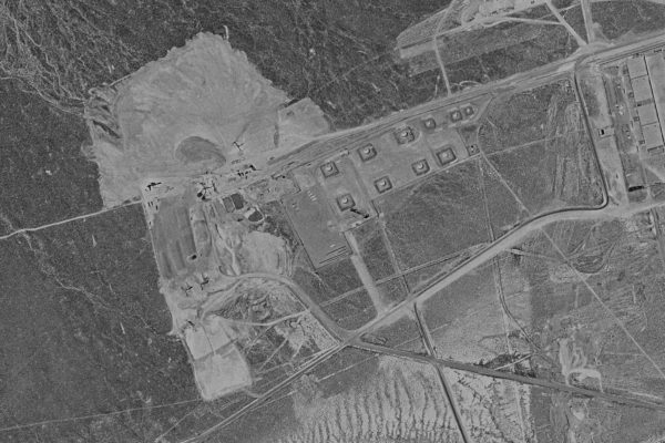
While other more secretive installations exist, the public has been fascinated with what occurs at Area 51. The military installation sits north of Los Vegas, Nevada, and has been the birthplace of many of America’s most advanced acknowledged craft, such as the U-2 spy plane and the SR-71.
So secretive, in fact, is the base that when an astronaut aboard Skylab, an American crewed space station, in 1973 inadvertently took a photo of the general area from space, it sent the Central Intelligence Agency (CIA) into a frenzy. The photo was ultimately made available and released, though it’s unlikely it would have given the general public any significant insight as to what went on at Groom Lake, another name for the installation; it wasn’t officially acknowledged by the Air Force until the end of the 20th Century.
The base was regularly the target of Soviet Spy Satellites, including Zenit, which like its American equivalent, captured views of Earth from space on film to be deorbited, recovered, processed and analyzed for actionable intelligence. The two countries tracked each other’s launches and could calculate when opposing satellites were overhead, allowing each to halt ongoing activities or in typical Cold War fashion, place models of fake planes, for example, to deceive the other of ongoing military developments. Such tactics often worked in favor of the United States and against the Soviet Union, such deceitful acts against American reconnaissance overflights typically meant further budget allocations and procurement while for the Soviets, it meant continuing a legacy of fraud and trickery that worked against the eastern power. The Soviets, however, often superseded the United States with human intelligence further necessitating an advantage in signals intelligence.
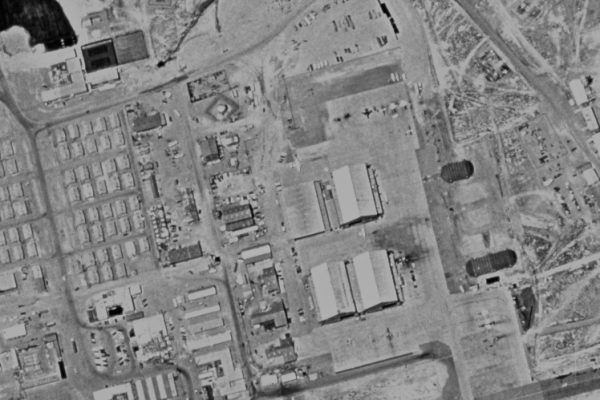
While it’s all but a guarantee that the Soviets, and also the Chinese, have far more satellite captures of Area 51 and various other secretive American bases, so far only the United States has chosen to create a process for declassification and public access. American satellite archives have allowed detailed studies of everything from climate change, which tracks the retreat of sea ice, to ancient ruins throughout the world. As a democracy that promotes freedom of information for its people, the United States has done more than any other country in this regard. These images were never intended to be seen by the public, let alone citizens of foreign nations, but now such archives are the cornerstone of various scientific pursuits. Everyone from Russian military historians to Chinese urban planners use the American captures for their research because their respective nations have yet to declassify and open up their archives for study, which would also show the United States had superior film-based spy satellites during that era.
Area 51 was so secretive in its day that those tasked with analyzing American spy satellite imagery did not have the clearance to see photos captured over Groom Lake. Frames showing such areas of strategic national importance were physically cut out of their film strips and held in separate secure repositories. Many of those captures remain held away to this very day. Scouring the public archive, it becomes apparent that spots all over the world are missing from declassification. Lop Nur, for example, where China tested its nuclear weapons, has never been released. The same can be said about many areas of particular military interest from the former Soviet States as well as spots in South America to some right here back at home. Multiple frames are missing south of Zanesville, Ohio, for example; the government doesn’t have an official explanation though research shows the CIA used the town for various Top Secret operations during the First Cold War, including testing our most advanced spy satellites.
Take for example a KH-4 American spy satellite capture of Area 51 on December 21, 1968, 58 years ago, it’s still missing from the archive; in its place is a black film strip with the words, ‘frames edited from original negative,’ no further explanation is given. On other capture dates, such as on May 29, 1970, the frame is left for public access, but in a sort of national security irony, it’s a fully cloud-covered image and worthless for any sort of analysis. In other program iterations, such as with KH-9, imagery has been more freely released – overflights are available but only one has been requested for full-resolution scanning; intriguingly, later years are also missing, or it’s possible, they were never tasked for observation over Groom Lake after KH-11 electrical-optical satellites entered service – that program remains classified, so it’s impossible to know for sure.
The special capture of Area 51 seen throughout this article is not in the public archive, but it has been declassified. It sits along with other frames of America’s most important sites, technically declassified but only available for special case publication, therefore, we can’t provide a date or additional details surrounding the photos provided herein except to state they were legally acquired. Unlike the downloadable spy satellite capture of Area 51, taken by a KH-9 satellite on June 6, 1971, our photograph shows multiple aircraft around the base and it busy with activity. More importantly, it’s what it doesn’t show, the underground facilities. There are only a few examples of public officials or those with direct knowledge discussing such construction projects, the government won’t speak on the record about it.
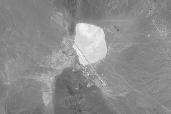
The first publicly accessible view of Area 51 from space came from Franch’s Spot 1 electro-optical imaging platform, its first, in 1986 – the year it was launched. The advancement shocked the world as unlike the Americans, Soviets and Chinese, France made the images available for public consumption in an attempt to curtail Russia’s monopoly in selling high-resolution images of the world in exchange for hard currency. The platform, which offered 10-meter resolution in panchromatic mode, far exceeded what the Americans were making available to their scientists and citizens with Lansat. At the time of Spot’s launch in February 1986, its American peer, Landsat 5, launched in March of 1984, offered 30-meter resolution in the blue, green, red and near-infrared spectrums; Spot 1 offered the same with 20-meter resolution. As a response, IKONOS was launched in September 1999 from Vandenberg Air Force Base in California, America’s first commercial imaging satellite, which offered a 0.80-meter panchromatic resolution and a 3.2-meter resolution multispectral image.
The public is left with movies like Independence Day, where President Thomas Whitmore is taken 24 floors below Groom Lake, to fantasize about what really goes on at the site. When asked why he was never briefed about it in the movie, Whitmore is simply told ‘plausible deniability.’ Back in reality, the most the American public will get is a word or two of too much information. Take for example former President Bill Clinton’s interview on The Late Late Show with James Corden, when the topic of Area 51 is brought up, President Clinton recalls his time as president and his attempt to find out as much as he could.
“When I was president and I had a Chief of Staff, John Podesta who loves science fiction, we made every attempt to find out everything about Roswell and I – we also sent people to Area 51 to make sure there were no aliens in the deep ele- ” President Clinton said on the show before quickly switching to saying how the base is very important for invisibility technology. Others like President-elect Donald Trump haven’t said much about the secret facility but promised on the Joe Rogan Podcast to declassify information on ‘people coming from space,’ offering up only that he was told a ‘lot about it’ after bringing up Area 51.
Project Blue Book, for example, which was run out of Wright-Patterson Air Force Base in Ohio, quickly discovered that nearly all cases of unidentified flying objects (UFOs) were top secret military craft, like the U-2 spy plane, but that couldn’t be told to the general public. Many cases weren’t given much attention, but when Zanesville barber Ralph Ditter showed photographs of a purported craft above his Roseville home, with news making its way around the world, the government was faced with a dilemma, they had to prove the photo staged. At the time, no one questioned why the RAND Corporation and the CIA put some of their best analysis at disproving the photograph and Ditter upon the overwhelming evidence, which included missing sequential Polaroid film and photos that were taken hours apart, admitted he had staged it for his daughter. What he and many others in Zanesville were never told was why his staged photographs got so much government attention and why his case file at the CIA remains mostly classified and heavily redacted to this very day. Intriguingly, photos of southern Muskingum County, including Roseville, were provided in the special archive, placed alongside some of the country’s most important installations.
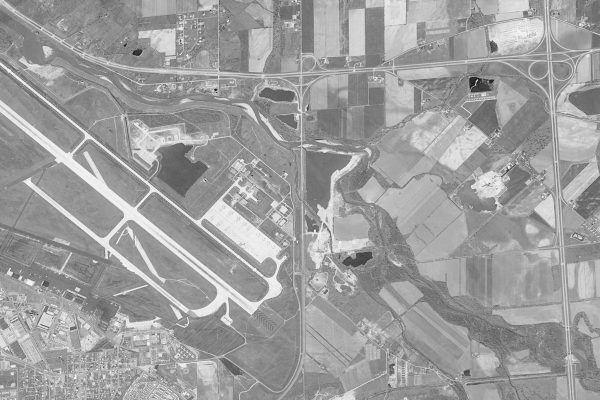
Throughout the years, Ohio has had its fair share of important installations, Wright-Patterson or the 180th Fighter Wing in Toledo are likely the ones known by many of the general public, but in the 1960s, the state featured AT&T’s L3 nuclear-hardened transcontinental cable, which was involved with transmitting launch orders that would surly end the world. Newark Air Force Base in Licking County played an integral part in the missile system that would deliver a nuclear weapon to its target, its guidance system. The Portsmouth Gaseous Diffusion Plant in Pike County enriched the uranium necessary for making those bombs.
When Google announced it was coming to Ohio, beating out many other states for the data centers that now power our everyday life, it came with excitement, but no one questioned why they were building three separate data center campuses, one in southern Columbus, one in New Albany and one in Lancaster; the only other place where a trio of such projects were constructed was Omaha, Nebraska, where Google is unofficially known to use them to support military and government projects.
Boeing, who now runs the Guidance Repair Center in Heath, has stated that the site is the second most geologically stable in the United States. It is only behind that of Cheyenne Mountain in Colorado which hosts the Cheyenne Mountain Complex, a defensive bunker. Just a few miles west of Boeing’s site, Intel has announced it will produce leading-edge chip factories; just south of that site, Amazon, Facebook and Google have colocated a massive data center farm, supported by unprecedented fiber capability.
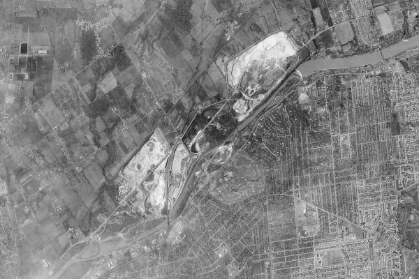
While searching through the satellite archives, west Columbus was captured by a KH-7 spy satellite on February 18, 1966. At the time of its capture, this particular satellite provided the highest resolution possible for target areas. Other nearby sites captured include Wright-Patterson in Dayton, Ohio, and Oak Ridge, Tennessee, home to Oak Ridge National Laboratory – where plutonium was produced from uranium; the satellite film was used very sparingly statewide, so the question persisted, what was so important west of Columbus in the 1960s?
Coincidentally, when AT&T built out their L5 nuclear-hardened communication cable from Xenia to Danville, they chose Hilliard to build an underground, property records and aerial photographs show it was built in the early 1970s. Around the same time, the West Side Railroad Station was built just south of the underground. The satellite imagery, which consists of two images, taken in stereo-pair, appears to be paying particular interest to that same area of development, including an adjacent quarry. It’s impossible to say precisely why the analysts had tasked the satellite to capture that particular area of west Columbus, but one clue may be that just south of the underground, Amazon has built not one but two separate data center campuses. Some area residents report old rumors of the government building a massive underground facility in Hilliard but others say it’s nothing more than just that, rumors.
The City of Columbus also hosts a military Defense Supply Center for the Defense Logistics Agency on a 530-acre site just south of the John Glenn International Airport.
The release of some of these highly restricted images, including that of Area 51, to Y-City News comes as American intelligence officials are sounding the alarm that America may soon face an attack on the homeland the likes of which will resemble Pearl Harbor or September 11 – attacks that united our country but also pulled us out of our isolationist mindset and drew our attention back abroad to ensure the next successful era of the American Empire.
When Pearl Harbor was attacked on December 7, 1941, America had already spent nearly two years ramping up military production, for our lend-lease agreements, to support the war effort by foreign powers to take on Germany. While it’s known that the United States had at least limited warnings of an upcoming attack, the question of whether intelligence officials knew Hawaii was the primary target remains classified and obscured; the reality, however, was that if the ambush had not occurred, according to declassified documents obtained after the war, that coastal cities of North America would have been subjected to aerial bombings by the Germans and likely naval bombardment by the Japanese.
Likewise, in the months leading up to September 11, 2001, intelligence agencies, both domestic and foreign, were warning administration officials that an attack was forthcoming. As previously documented by Y-City News, the concerns of a bombing or plane flying into the United States Capital were so severe during the Presidential Address to a Joint Session of Congress by newly elected President George W. Bush that Secretary of Veterans Affairs, Anthony Principi, was selected as the Designated Survivor. Unlike many of the selectees who are chosen for their unimportance to the administration, Principi was the first selected in years that resembled what many Americans would choose as president, an athlete and student council president at his high school, Principi attended the United States Naval Academy ultimately being sent to and serving in the Vietnam conflict, after his service to the country, he became a lawyer and served in various respected administrative roles within the civilian side of government. For the first time since the end of the First Cold War and possibly ever in American history, the Designated Survivor, Secretary Principi, was taken to an undisclosed location under a mountain, likely Mount Weather, but the former service member declined to further elaborate.
Interestingly, multiple continuity of government exercises were held that year as well, before the attacks of September 11. Such drills, according to press accounts, hadn’t been well tested since the breakup of the Soviet Union and the enjoyed peace dividend, however, for reasons that remain not fully understood, there was renewed interest in ensuring the government couldn’t be decapitated in the months before the attack. The succeeding involvement in both Iraq and Afghanistan secured the Middle East and kept oil flowing to our European and Asian allies and partners, as Russian demographics collapsed along with their military and economic power.
As the world once again enters a multi-polar world, with various world powers eyeing to control their spheres of influence, the Bretton Woods Agreement is in its final era. In the coming years, America’s involvement in NATO, thanks in part to the Russian-Ukraine War, will diminish, leaving Europe to handle most of its own affairs and defense. America, meanwhile, will refocus our attention on the Asia-Pacific and our near-peer aggressor, China. With Japan able to secure its own oil from the Middle East and a self-sufficient supply in North America, American investment in the region will come to much lower levels not seen since the end of World War II. This will ensure Chinese and Indian oil shipments, as well as other commerce via the sea, are not benefited by an American military presence, though America will likely support India as a counter to Chinese military buildup in the region.
While American intelligence officials are close-lipped concerning details about this significant warning of a forthcoming attack, it likely comes on the heels of multiple foreign powers now seeking to obtain nuclear weapons and a destabilizing world in which the United States is unable to provide worldwide security. While a specific target or targets are unknown, there is a worry that it may focus on President-elect Donald Trump, who has faced two prior assassination attempts; his running mate JD Vance has chosen to often stay away to ensure continuity of the forthcoming presidency. After the yearly State of the Union address, Presidential Inaugurations are some of the most prime targets for both foreign adversaries and terrorists alike. Often someone from the prior administration is taken to a secure location to be the event’s Designated Survivor; most secretaries in the line of succession have prefiled resignations that become effect at Noon on January 20. As it takes Senate confirmations to approve President-elect Trump’s nominees, an attack at the event would severely impact the incoming administration.
There are reports that recent success by the Israelis in the Middle East, including against the Iran-backed Houthis, has left the heavily sanctioned regime desperate and vulnerable. The country continues to advance its nuclear weapons program, which is seen as a hard line by Israel and other Middle Eastern powers, such as Saudi Arabia. The use of nuclear weapons by any power offensively, besides the United States, will not be tolerated; America has a vast array of options to deal with any power that should attempt to use such devices, including but not limited to the capability to disable the means of launch, in-flight separation and near target detonation.

